New Work

This website is primarily a collection of documentary photoessays published between 2007 and 2012 by Nathan Kensinger, exploring The Abandoned and Industrial Edges of New York City. His photo essays were then published from 2012 to 2020 as the column Camera Obscura at Curbed NY. Since 2020, Kensinger has continued to document New York City's changing landscape, in photographs, films, articles, and public art installations. His most recent photo essays have been published since 2020 at WNYC/Gothamist, New York City’s public radio station. To view all of Nathan Kensinger's work, visit the website www.nathankensinger.com

Managed Retreat


On August 25th, 2018, my latest documentary film, Managed Retreat, premiered at Rooftop Films. Managed Retreat is a short documentary portrait of three New York City neighborhoods that were purchased by the New York State government in the aftermath of Hurricane Sandy, to be demolished and returned to nature as part of the city’s first ‘managed retreat’ from rising sea levels. This observational documentary follows the process of retreat over the course of five seasons in three waterfront communities on Staten Island, as homes are destroyed, streets are abandoned, and wild animals begin to return.

Managed Retreat was inspired by my photographs of Oakwood Beach, Ocean Breeze and Graham Beach in Staten Island. These photographs have been published in a series of photo essays at Curbed NY, and have been featured in Nature Climate Change and the PBS Newshour.

Managed Retreat is now screening at film festivals and being exhibited in galleries worldwide, including screenings at the Imagine Science Film Festival, Environmental Film Festival Australia, and Princeton Environmental Film Festival.

More details on the film can be seen at: www.managedretreatfilm.com

The Fifth Anniversary of Hurricane Sandy


October 2017 - 


When Hurricane Sandy made landfall in New York City five years ago, it caused massive devastation in many of the unique coastal communities that had been documented on this website. In the five years since the storm, many of these communities have undergone a radical transformation. Some have been almost entirely rebuilt, after being crushed and burned to the ground during the storm surge. Others have been demolished as part of a managed retreat from the waterfront. The entire coast of the city has undergone enormous changes, and will change even more dramatically in the years to come, as larger storm barriers are built and as sea levels continue to rise.  

The following is a chronological list of my photo essays from the past five years about the changes that have occurred along New York City's waterfront since Hurricane Sandy. They were all published by the website Curbed NY as part of my ongoing column Camera Obscura, which was begun in 2012, just a few months before the storm. 


2012

Surveying Sandy's Damage in Red Hook, Dumbo, and Gowanus (October 2012)
A Look at the Post-Sandy Cleanup in the Rockaways (November 2012)
Surveying Sandy's Damage to Staten Island One Week Later (November 2012)
Surveying Queens' Rockaway Peninsula After the Storm (Novermber 2012)


2013
Wondering What Hurricane Sandy Means for Red Hook's Future (January 2013)
How the Newtown Creek Area is Faring After the Storm (February 2013)
How Dumbo's Arts Spaces Have Recovered From the Storm (February 2013)
Coney Island's Boardwalks and Beaches Prep for Memorial Day (May 2013)
Demolition and Recovery in the Post-Sandy Rockaways (May 2013)
Tracing The Scars of Hurricane Sandy on Staten Island (April 2013)

Coney Island's Residents, Forgotten, Struggle to Recover (October 2013)
Abandoned Buildings, Red Tape Mark a Year on Staten Island (October 2013)
Tracing A Post-Storm Year of Change in the Rockaways (October 2013)


2014

Fort Tilden Beach Reopens to a Changing Neighborhood (July 2014)
Breezy Point Residents Choose to Remain and Rebuild (October 2014)
Two Years On, Coney Island Enclave Still Awaits Recovery (October 2014)
Residents Retreat From Staten Island's Hard-Hit Waterfront (October 2014)

2015
Tracing Post-Storm Recovery in New York and New Orleans (January 2015)
What Comes Next for the Changing Coney Island Boardwalk? (July 2015)
Is This The End of the Brooklyn Bungalow? (August 2015)
Rockaway Boardwalk Re-emerges With a New Identity (August 2015)

The Slow Resurgence of the Rockaway Bungalow (September 2015)
Three Years After Sandy, Returning Staten Island to Nature (October 2015)

2016

Forecasting the Future on NYC's Climate Change Frontlines (March 2016)
Can Auction Transform a Storm-Damaged Corner of Staten Island? (April 2016)
A small Queens community confronts climate change along Hawtree Creek (September 2016)
Four years after Sandy, Staten Island's shoreline is transformed (October 2016)
On Staten Island, a centuries-old waterway helps shape new wetlands (December 2016)

2017

Climate change in Trump’s NYC: How at-risk neighborhoods are combating rising sea levels (January 2017)
A long-neglected Queens neighborhood grapples with the effects of climate change in NYC (April 2017)
Imagining a New York City ravaged by climate change (May 2017)
In Queens and Staten Island, two competing visions for New York's waterfront (June 2017)
In Queens, chronic flooding and sea-level rise go hand in hand (October 2017)
Hurricane Sandy five years later: Brooklyn’s Sea Gate is stuck in a middle ground (October 2017)
Hurricane Sandy five years later: Rebuilding in Breezy Point (October 2017)
Hurricane Sandy five years later: A Staten Island neighborhood transformed by ‘managed retreat’ (October 2017)
Five years after Hurricane Sandy, NYC's coastal communities remain vulnerable (October 2017)


To Quench the Thirst at The Museum of the City of New York


From September 2, 2017 to December 31, 2017, the exhibit "To Quench the Thirst of New Yorkers: The Croton Aqueduct at 175" will be on view at the Museum of the City of New York. This exhibit traces the history of the Croton Aqueduct from the 1800s to present day, presenting historic drawings, paintings and letters from the museum's collection alongside a newly commissioned set of ten photographs taken by Nathan Kensinger. These photographs explore the present day condition of the aqueduct, tracing its route from the Croton Reservoir to Manhattan, and are presented alongside original 1800s drawings of the aqueduct by engineer Fayette Tower. These photographs present modern views of the aqueduct from towns all along the Hudson, including Ossining, Irvington and Hastings on Hudson, and include a glimpse of the interior of the original brick lined structure, now nearly empty of water. 


Shifting Perspectives at the Brooklyn Historical Society


From May 19, 2017 to September 10, 2017, the exhibit "Shifting Perspectives: Photographs of Brooklyn's Waterfront" will be on view at the Brooklyn Historical Society's new space in Dumbo, Brooklyn. This exhibit features the work of 25 photographers, from the 1930's to present day, including Berenice Abbott, Rudy Burckhardt, Bruce Davidson, Morris Engel & Chester Higgins, Jr.

Four of Nathan Kensinger's photographic prints are presented in the exhibit, along with five photographs included in a gallery slideshow. These images are selections from Kensinger's ongoing documentation of New York City's waterfront, and range in date from 2007 to 2016. They include photographs from the Domino Sugar Refinery in Williamsburg, Dry Dock One in the Brooklyn Navy Yard, the Gowanus Canal, Sea Gate, Coney Island Creek, and Dead Horse Bay.

"Shifting Perspectives" was curated by Marilyn Symmes. The Brooklyn Historical Society writes of the exhibit: "This exhibition features the work of two dozen photographers whose images crisscross the Brooklyn shoreline, from Newtown Creek to Jamaica Bay. By picturing decades of Brooklyn’s coastal scenery, including its changing industrial and postindustrial environment, the exhibition presents dramatic panoramic vistas; spectacular aerial views; glimpses of popular recreational attractions, particularly in nearby Brooklyn Bridge Park and at Coney Island; and other scenes, including those impacted by natural or manmade forces, as well as by gentrification."

Tenth Anniversary


March 2017 -

This month marks the tenth anniversary of an ongoing series of photo essays which started at this website in March 2007. Published every two weeks for the past decade, these essays capture a period of remarkable change along New York City's waterfront, as many of the industrial relics of the past century were removed to make way for new residences and parks at the water's edge, even as sea level rise, climate change, storms, and economic forces radically reshaped the city.

These photo essays started as a personal project to document the rapid transformation of Brooklyn's coastline, and have since expanded to capture change in all five boroughs, and in other coastal cities. Initially intended to show unseen aspects of the contemporary landscape, they have since taken on a historic value, with hundreds of thousands of photos cataloging lost landmarks and disappearing neighborhoods. These essays have been exhibited in museums and libraries, have been published in all of New York City's major periodicals, and several of these photos are in the permanent archives of the Museum of the City of New York, the Brooklyn Historical Society, and the Brooklyn Library.

These essays are currently published as the Camera Obscura column at Curbed NY.  The first five years of essays are archived at this website, while the most recent five years can be seen at Curbed. A complete list of all 212 photo essays has been amassed here. As the evolution of the city continues, this archive of photo essays will continue to grow.


Industrial Twilight: Photographs of the Changing Brooklyn Waterfront


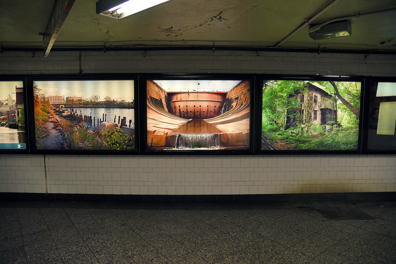
From August 26, 2016 to Fall 2017, the exhibit "Industrial Twilight: Photographs of the Changing Brooklyn Waterfront" will be exhibited in the Atlantic Avenue Subway Station. This solo exhibit of Nathan Kensinger's photographs presents a retrospective of his work from the past decade, documenting the post-industrial coast of Brooklyn. "Industrial Twilight" was curated by the MTA Arts & Design program, and presents eight photographic transparencies, each printed six feet wide and installed in a backlit Lightbox.

"The images in Industrial Twilight show us the eerie stillness of places where industry thrived, from Sunset Park to Williamsburg and the Brooklyn Navy Yard," writes the MTA. "Kensinger finds poetry in these places and leaves a lasting reminder that while change is constant, history surrounds us with a reminder that before Brooklyn became a “brand”, it was an economic engine that employed thousands of people. Kensinger's images reveal a lone canoeist gliding down the Gowanus Canal past a concrete plant still going strong with the F train in the background, and images of the pre-transformation waterfront at Bush Terminal and the Domino Sugar Refinery. The architecture and lighting in the images of the Brooklyn Army Terminal and Greenpoint Terminal Market provides a haunting but reverent look at the borough in this moment of time, while an overgrown home at Admiral’s Row reflects that growth is never ending, and the waterfront still captures the imagination of the borough."

This exhibit was sponsored by Griffin Editions and Kodak Alaris. For more information on Industrial Twilight, visit the MTA Arts & Design exhibit page.



Chance Ecologies - 2015-2016


Summer 2015 - Summer 2016

Since 2015, I have been co-curating Chance Ecologies, an ongoing project creating a framework for artistic practices exploring unplanned, post-industrial wild spaces in New York City.  This project began with a summer-long investigation of Hunter's Point South, Queens in 2015, led by Catherine Grau and Stephen Zacks and myself.  In 2016, it expanded into an exploration of the Flushing River, curated by Catherine Grau and myself as part of a 6-week-long artists residency at the Studio In The Park at the Queens Museum, and an exploration of the Newtown Creek for the Queens Museum's exhibit Nonstop Metropolis: The Remix. Together with a group of over 20 international artists based in Brooklyn and Queens, Chance Ecologies has created an invaluable archive of materials from these unique parts of the city's waterfront. In October 2016, this work was exhibited at the Queens Museum in a new group show titled Chance Ecologies: Queens.

For more information on Chance Ecologies, visit www.chancecologies.org


New York's Abandoned Landmarks & Endangered Vernacular Architecture


October 2015 -

Over the Spring and Summer of 2015, Curbed NY published a series of my photo essays about New York City's endangered vernacular architecture and abandoned landmarks, for my column Camera Obscura. Written as the city celebrated the 50th anniversary of the landmarks law, these essays explored some of the important places that remain unprotected in NYC, including historic structures that the Landmarks Commission has refused to designate, as well as officially designated Landmarks that have been abandoned and left to collapse. In both cases, the fates of these important structures have been left to the whims of developers and city agencies.

These photo essays included everything from 30 year old Bronx casitas to 1930's bungalows & boardwalks to the 19th century officer's houses of Admiral's Row, the famed Fulton Fish Market, and a collections of civic structures - schools, courthouses, police precincts - which are now facing demolition, collapse, or redevelopment.

A link to each photo essay is included below:

- In the Bronx, Art Fills an Abandoned Neighborhood Landmark (April 2015)
- What's Next for New York City's Many Abandoned Landmarks? (May 2015)
- Revisiting Brooklyn's Abandoned Admiral's Row Before It's Gone (June 2015)
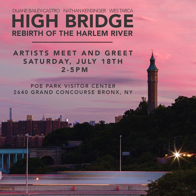
- As High Bridge Reopens, a Neglected Park Remains in Its Shadow (June 2015)
- What Comes Next for the Changing Coney Island Boardwalk? (July 2015)
- Rockaway Boardwalk Re-emerges With a New Identity (August 2015)
- Is This The End of the Brooklyn Bungalow? (August 2015)
- The Slow Resurgence of the Rockaway Bungalow (September 2015)
- Inside the Casitas of the South Bronx's Community Gardens (October 2015)


Documenting A Decade of Destruction


March 13, 2015 -

Ten years ago today, I decided to explore an abandoned powerhouse in Long Island City. It was not my first time inside an abandoned building, but it was the first time I purposefully brought a camera with me to photograph the space. Roaming through the old structure, into empty offices, dusty tennis courts, 275-foot smokestacks, and a turbine hall with a missing roof, I captured the initial images for a documentary project that has continued throughout the past decade.

125,000 photographs later, this project is still evolving and expanding. Begun as an attempt to document the rapid destruction of New York City's industrial heritage in the new millennium, this growing collection of photographs cohered two years later into a series of photo essays, published online once every two weeks since March 13, 2007. There are now 170 original photo essays in this series, documenting New York City's abandoned and industrial edges on this website, and at my Curbed column Camera Obscura, which began in 2012.


Over the years, the focus of these essays has changed from Urban Exploration adventures inside post-industrial ruins, to portraits of decaying and demolished neighborhoods, to considerations of how humans are altering the natural landscape, especially along the waterfront. Ultimately, the project has grown to become a large scale portrait of the specific effects of the Anthropocene Era within New York City, chronicling the permanent impact of humans on the environment, from the industrial revolution to today.

The Long Island City Power Station, built in 1906, was a coal powered facility that ceased operations in the 1920's and became home to the Schwartz Chemical Company in the 1950's. Shortly after I visited it, the building was partially demolished, like many of the city's other century-old powerhouses, refineries, silos, factories, warehouses and garages, which I have also photographed. Yet even as the aging structures of the industrial revolution are swept away from the American landscape, the ongoing impact of the pollution caused by human activities continues to shape our future. Radiation, oil spills, chemical waste and sewage overflows are all daily realities in New York City, and are helping to cause the sea level rise that will bring more storms like Hurricane Sandy.


In the context of human history, or of a geologic era, 10 years is nothing. But within the past decade, an enormous amount of change has occurred, both in the built environment and in our understanding of the impact we are having on the globe. In the brilliantly illuminating book "The Sixth Extinction," published in 2014, Elizabeth Kolbert explores the meaning of this period of time, as it exists within the Anthropocene, the current geological era that is only now being recognized: "Even a moderately competent stratigrapher will, at the distance of a hundred millions years or so, be able to tell that something extraordinary happened at the moment in time that counts for us as today. This is the case even though a hundred million years from now, all that we consider to be the great works of man - the sculptures and the libraries, the monuments and the museums, the cities and the factories - will be compressed into a layer of sediment not much thicker than a cigarette paper."


New York City's Forgotten Waterways


December 2014 -

As 2014 comes to a close, Curbed NY has published the final installment of my recent mini-series about New York City's forgotten waterways. This series explores lesser-known waterways in all five boroughs of New York City, including Staten Island's Lemon Creek, Brooklyn's Coney Island Creek, Queens' Hook Creek and Flushing River, and the Harlem River, which flows between Manhattan and the Bronx.

As sea levels continue to rise worldwide, New York City is in the process of reconsidering its relationship with the water that surrounds it. Each of these photo essays explores a different aspect of the city's plans for the waterfront, while examining issues of pollution, flooding, resiliency and access. This series documented many the city's new waterfront parks, wetlands and marshes, while also telling the stories of communities living on the water's edge.

A link to each photo essay is included below:

- New York's Once-Neglected Harlem River Experiences a Rebirth (Sept. 2014)
- Queens Forgotten River Looks Ahead to Cleanup and Change (Oct. 2014)
- Coney Island's Untamed Creek, Caught Between Past and Future (Nov. 2014)
- Following Hook Creek Through Ghost Towns and Wetlands (Dec. 2014)
- Little-Known Lemon Creek Winds Through Staten Island History (Dec. 2014)


Photographing The Post Sandy Shoreline


October 2014 -

For the second anniversary of Hurricane Sandy, Curbed has published my three part photo essay looking at how New York City's waterfront has been transformed since the storm. This series of photo essays - collectively titled The Post-Sandy Shoreline - looks at the divergent recovery efforts in three different areas that were hardest hit by the storm - Breezy Point in the Rockaways, Sea Gate in Brooklyn and Oakwood Beach and Ocean Breeze in Staten Island.  These photo essays encompass two years of photographic work, tracking the progress made since Hurricane Sandy devastated New York's waterfront. They can be viewed at Curbed using the following links:

- Breezy Point Residents Choose to Remain and Rebuild
- Two Years On, Coney Island Enclave Still Awaits Recovery
- Residents Retreat From Staten Island's Hard-Hit Waterfront

Fluid at Newhouse Center For Contemporary Art


From May 2014 to January 2015, the Newhouse Center For Contemporary Art will be exhibiting video and sculpture from The Newtown Creek Armada as part of the group exhibit Fluid – Essential For Life. The exhibit, located at the Snug Harbor Cultural Center & Botanical Garden in Staten Island, was "inspired by the symbiotic relationship of Snug Harbor with water – from its location directly across from New York Harbor to its 10 acres of wetlands to the Koi pond at the New York Chinese Scholar’s Garden to the fountains of the Tuscan Garden and all the way back to its beginnings as a home for retired sailors."

More information on Fluid can be seen here.

Combined Overflow at Proteus Gowanus


From April 26th to May 24th, 2014, the exhibit "Combined Overflow" was on view at Proteus Gowanus in Brooklyn.  Combined Overflow was a group exhibition of creative responses to the Newtown Creek and the Gowanus Canal, two New York City waterways with similar histories of industry, pollution and neglect. Both of these salt-water inlets were designated as federal Superfund sites in 2010, and are currently undergoing remediation, even as new residents are lured to their shorelines. Both have also inspired dedicated communities of artists, innovators and explorers, who have been working to collectively recalibrate these bodies of water as fertile sites of collaboration, invention and public engagement.

Combined Overflow included 20 different projects created by artists including Wendy Andringa, Liz Barry, Sarah Christman, Willis Elkins, Eymund Diegel, Jose Gaytan, Jan Mun, Leif Percifield, George Trakas, Mitch Waxman and Jenifer Wightman, and groups including Brooklyn Atlantis, The Gowanus Canal Conservancy, The Gowanus Dredgers Canoe Club, The Newtown Creek Alliance, The Newtown Creek Armada, The North Brooklyn Boat Club, and Urban Omnibus.

Combined Overflow was curated by Nathan Kensinger, Laura Chipley and Sarah Nelson Wright of The Newtown Creek Armada. The triptych image above includes work by Jose Gaytan, Willis Elkins and Jenifer Wightman. For more information on Combined Overflow, please visit Proteus Gowanus and read this review of the exhibit at Untapped Cities.

Remote Voyages


From November 7th to 23rd, 2013, the video installation "Remote Voyages" was on view at the 111 Front Street Galleries in Dumbo, Brooklyn.  Remote Voyages was an exhibit created from video shot during The Newtown Creek Armada, a 2012 public art installation that was created in a collaboration between Nathan Kensinger, Laura Chipley and Sarah Nelson Wright.  The Armada invited the public to a engage in a remote-control boat pond built on the Newtown Creek, one of the most polluted bodies of water in the United States.  Remote Voyages presented immersive voyages created during that boat pond, projected onto the gallery walls from boats floating in water.

For more information on Remote Voyages, please visit www.newtowncreekarmada.org

Rising Waters and Documenting Sandy


October 29, 2013 -

On the one year anniversary of Hurricane Sandy, two new exhibits will include selections of my photographs from the aftermath of the storm. The first is titled "Rising Waters: Photographs of Sandy" and will be open at the Museum of the City of New York from October 29th, 2013 through March 2, 2014. The second is titled "Documenting Sandy" and will be open at the Brooklyn Historical Society from October 30th to Spring, 2014. 

For the past year, I have been documenting the post-Sandy recovery efforts, tracing the progress made in Staten Island, the Rockaways, and several Brooklyn neighborhoods. These photographs have been published in a series of photo essays at "Camera Obscura" - my column for Curbed - and have also been exhibited at "Silent Beaches, Untold Stories: New York City's Forgotten Waterfront." This ongoing documentation revisits numerous neighborhoods that had been photographed for this website, before the storm. 

The above photograph, taken in Midland Beach, Staten Island in April 2013,  is included in "Rising Waters," an exhibit of 200 photographs selected by a jury from work submitted by over a thousand photographers.

Gowanus Voyage at Proteus Gowanus


On September 15th, 2013, Proteus Gowanus opened an exhibit featuring underwater video and scientific data collected during Gowanus Voyage, a public art installation staged on the Gowanus Canal in July 2013 by The Newtown Creek Armada and Brooklyn Atlantis.  This exhibit is a part of the Hall of the Gowanus, "a mini-museum and gallery of art, artifacts, maps, documents and books" dedicated to the history of the Gowanus Canal, and will be on view into 2014.

Gowanus Voyage's public art installation was initially created as part of the Metropolitan Waterfront Alliance's City of Water Day with the support of the Gowanus Dredgers Canoe Club, and the participation of the Gowanus Canal Conservancy and Proteus Gowanus. It was created in a collaboration between Jeffrey Laut of Brooklyn Atlantis, and Laura Chipley, Nathan Kensinger and Sarah Nelson Wright of The Newtown Creek Armada.
 

Silent Beaches, Untold Stories: New York City's Forgotten Waterfront


From September 3rd to November 9th, 2013, St. John's University featured my photographs of New York's waterfront in a group exhibit titled "Silent Beaches, Untold Stories: New York City's Forgotten Waterfront." This exhibit, curated by Elizabeth Albert, was "an interdisciplinary exhibition exploring waterfront areas that are remote, neglected, or little known to the general public and which have experienced long and sometimes tumultuous relationships with New York City’s changing needs."  The exhibit included a wide selection of my photographs from the past seven years, alongside the work of eight other artists, including Marie Lorenz of the Tide and Current Taxi and photographer Joel Meyerowitz.

An opening reception for "Silent Beaches, Untold Stories" took place on September 19th, 2013 at the Dr. M. T. Geoffrey Yeh Art Gallery at Sun Yat Sen Hall on the St. John's University campus in Queens, New York. An artists panel took place on October 10th, 2013.  For more information on the exhibit and events, please visit the exhibit's homepage

Gowanus Voyage


On July 20th, 2013, "Gowanus Voyage" was launched from the banks of the Gowanus Canal. Gowanus Voyage was an interactive public boat pond created in a collaboration between The Newtown Creek Armada and Brooklyn Atlantis. This public art installation invited visitors to explore above and below the surface of this historic waterway by piloting miniature remote control boats and aquatic robots from the shoreline. These watercraft were equipped with video cameras and environmental sensors, and the footage and data collected at this daylong event will be presented at a later exhibit.
Gowanus Voyage was presented as part of the Metropolitan Waterfront Alliance's City of Water Day with the support of the Gowanus Dredgers Canoe Club, and the participation of the Gowanus Canal Conservancy and Proteus Gowanus. The event included public presentations by these groups, including an aerial observation balloon. Gowanus Voyage set sail from the Gowanus Dredgers boat launch near Bond Street in Gowanus, Brooklyn.

The Edges of Barcelona


March 13, 2013 -

At the edges of many great cities, the social fabric begins to unravel.  Far from the densely packed urban core, the individual threads of the city tapestry become visible. The extremes of poverty and wealth. The conflicts of industry versus nature, pollution versus wilderness. New development, empty lots, vernacular architecture, towering mansions, abandoned buildings, forgotten landmarks, bomb shelters, villages, graveyards. All of these things can exist at the city center, but they become much more apparent in the isolation of the edges.

The edges of these same cities are often actively hidden from visitors.  Maps are created especially for outsiders that focus on the center. A truncated version of city boundaries is presented. Tourist zones are created, offering up an urban experience designed by the governing bodies. These zones are often located at the historic heart of the city, a region that is known, controllable, and organized. Here, the authorities can present their vision of a city identity, one that they are heavily invested in maintaining.  In New York, this tourist zone is in lower Manhattan and Times Square. San Francisco's zone is Fisherman's Wharf, Seattle has Pike Place Market, New Orleans has the French Quarter, and Havana is focused on its old city center, Habana Vieja. In Barcelona, the central tourist zone is situated around the Gothic Quarter, a warren of narrow alleys and small shops crowded day and night with out of town visitors.

Barri Gòtic, Barcelona

The Gothic Quarter, where the Romans built their city walls, is much like lower Manhattan, where the residents of New Amsterdam lived behind their own walls. From this tightly packed historic center, a more modern city has radiated out. From Manhattan, New York City spread out to annex its neighboring cities and towns, creating the five boroughs. In Barcelona, the modern city was created in a series of concentric circles - like Paris - moving out from its old core to overtake the small villages and towns surrounding it. The Barcelona that most visitors know today - Gaudi's architecture, La Rambla, the Eixample, the city beaches - is within short walking distance of the Gothic Quarter. The tourist map is also centered here, and does not extend out to the edges of the city. 

As in New York, the outskirts of Barcelona are excluded from regular guidebooks and left to the poetic imagination, explored in works like "Secret Barcelona" and "Barcelona Noir." Scant mention can be found in mainstream publications of the neighborhoods along Barcelona's fringes. What mentions there are often devote just a sentence to a neighborhood's history, usually with a dire warning. "To be avoided." "A shantytown." "Dangerous." It is the same story in many large cities. The neighborhoods at the edges are unknown to visitors, sidelined by the government, and remain a mystery even to nearby residents. And in the side streets of these neighborhoods, the unwritten story of the city can be seen.

Vernacular Sarria #1


Vernacular Sarria #2

In Barcelona - like many cities - these neighborhoods are not particularly hard to find, although it is sometimes difficult to catch more than a glimpse into their stories. They include places like the far side of Montjuïc, where over 150,000 hand-decorated tombs are stacked onto a steep hillside, looking out over the blue waters of the industrial port. In nearby Poble Sec, the neighborhood bomb shelter built underneath Montjuïc is one of the last surviving shelters from more than 1,400 built in Barcelona during the Spanish Civil War. Further into the hills above the city, the winding streets of the village of Sarria lead to dead ends and empty lots, a contrast to wealthy monasteries and mansions hidden behind walls nearby. Above Horta, outside the outer ring road, narrow vegetable gardens are carved into canyon walls near an abandoned home and a forgotten cemetery. Below, in the densely packed row houses of Nou Barris, each unique home is a single floor, sharing a common wall with all of the neighbors. Closer to the ocean, in the crumbling industrial ruins of Poble Nou, squatters and artists are being displaced from old factories by new development, a story familiar to cities around the world. And at the edge of town, where the Besos River meets the sea, children swim in factory outflows, as noxious chemicals are pumped out into the Mediterranean.

Throughout the city of Barcelona, a constant whir of cranes and the pounding of jackhammers makes it clear that all of these unique neighborhoods are under threat of replacement, to be transformed into the gleaming modern glass towers that have eviscerated many of the greatest cities of the world.


---
On the 6th anniversary of this website, this photo essay is dedicated to Keary and Kathy Kensinger, in gratitude for all of their generosity, support, and encouragement. 


Cementiri de Montjuïc, Barcelona


#2257 - Overgrown Tomb


#2018 - Propiedad Funeraria


Angel Head


Above Montjuic Cemetery


Industrial Port


Poble Sec Bomb Shelter


 Refugi 307


Under Pedralbes Monastery


Pedralbes Monastery Well


 Horta Cemetery Tomb


 Cementiri d'Horta


 Horta Ruin


 Nou Barris Row Houses


 Nou Barris Neighbors


Poble Nou Protest


Poble Nou Ruin


Poble Nou Demolition


Community Garden, Poble Nou 


Abandoned Church, Poble Nou 


Factory Ruin, Poble Nou