The Bloomberg Era, Part One

What Has Been Lost
In the last decade, the skyline and landscape of New York City have been completely transformed. During a 7-year-long real estate boom, which collapsed in 2008, thousands of demolition permits were issued, thousands of new buildings were constructed, and thousands of businesses opened and closed. No neighborhood was left untouched by this boom and its subsequent bust. One man oversaw most of these changes: Mayor Michael Bloomberg, who came to power in 2002. Not since Robert Moses has a single individual presided over such a large-scale transformation of New York City's built environment.
The changes truly began on September 11th, 2001, with the destruction of the iconic Twin Towers of the World Trade Center. This unexpected and traumatizing blow to the New York skyline was followed one month later by the election of Michael Bloomberg. On January 2nd, 2002 Mayor Bloomberg was sworn into office, with the NY Times declaring "The Bloomberg Era begins... times will be tough and sacrifices will need to be made." Few would guess, during this post-9/11 period of mourning, that an era of prosperity and construction unlike many others in New York history would follow. In 2008, the NY Times would describe it as "seven years of nonstop construction, skyrocketing rents and sales prices, and a seemingly endless appetite for luxury housing that transformed gritty and glamorous neighborhoods alike."

This construction boom created an equal boom in demolitions. According to The Real Deal, "during the recent building boom, the number of demolition permits rose from 3,386 in 2002 to a high of 6,480 in 2006. The number fell in 2007 to 5,582..." Among the thousands of structures lost over the last decade were many familiar landmarks in the New York skyline, particularly along the edges of New York City. All along the waterfront, from the South Bronx to the Far Rockaways, neighborhoods were affected by the development gold-rush.
As documented by this website, many historic structures were demolished along the industrial waterfront to make way for developers. Neighborhood icons vanished, like the smokestacks of the Long Island City Powerhouse, erased from the skyline in 2005 by luxury condominiums. In Brooklyn, the rapid pace of development claimed so many historic structures that by 2007, the National Trust for Historic Preservation placed Brooklyn's entire industrial waterfront at the top of their list of "America's 11 Most Endangered Places," stating "historic dockyards and factories are being demolished by developers anxious to cash in on the area's newly hip status." Some of the industrial structures lost included the Greenpoint Terminal Market - a potential landmark which was partially burned to the ground in 2006; the Todd Shipyard - a working shipyard demolished in 2006 by Ikea; the Revere Sugar Refinery - a neighborhood icon which guided ships into the Eerie Basin until being demolished in 2007, and the Kent Avenue Powerhouse - a grand structure completely demolished by 2009. Many of the industrial buildings destroyed throughout the decade were functional, stable, useful structures that could have been redeveloped and given a second life.


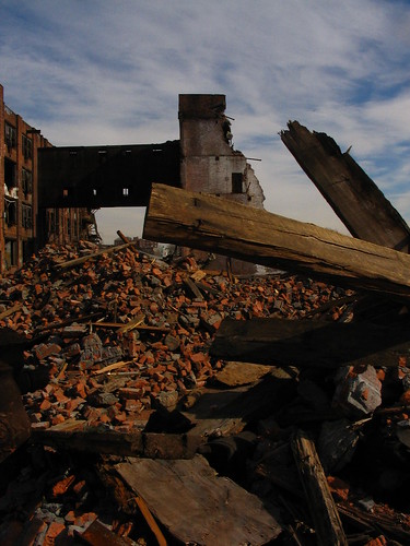

In a previous era, New York's Landmarks Preservation Commission (LPC) was formed to help defend grand spaces such as these from developers. While some important structures were landmarked in the last decade, including parts of the historic Domino Sugar Refinery, the LPC failed to take a leading role during the development boom. In a 2008 editorial, the NY Times slammed the LPC, saying "the Landmarks Preservation Commission should be a vital part of the planning process in New York City. Instead, it has become a bureaucratic black hole... the landmarking process is routinely outflanked by developers." Additionally, it was shown that landmark status offered no true guarantee of protection, as the LPC reversed its protection of certain designated landmarks, like St. Vincent's Hospital in 2008, or in other cases allowed designated landmarks to slowly collapse, as on the grounds of Bayley-Seton Hospital in Staten Island.
Into the void left by the Landmarks Preservation Commission stepped a small army of concerned citizens. Numerous websites were launched mid-decade to report on what neighborhoods were losing to developers, including Gowanus Lounge, EV Grieve and Lost City. Local historians like Kevin Walsh of Forgotten New York continued to document the obscure, endangered corners of the city. Groups like the Municipal Art Society, the Metropolitan Waterfront Alliance and the Society for Industrial Archeology launched campaigns to save many potential landmarks.


Bayley-Seton Hospital (2008)
 East Village Grief
New York's once colorful commercial landscape was also transformed by the development boom. As property values rose, landlords began "imposing double-digit rent increases," according to the NY Times, squeezing older mom and pop stores out of many neighborhoods. In 2004 alone, according to City Limits, "the city lost 10,000 small businesses." By 2009, New York's streetscape had completely changed, as captured in James and Karla Murray's haunting photography book "Storefront." According to the Murray's, "we included over 225 stores in the book but have photographed hundreds more since we started photographing the mom and pops over 10 years ago. More than half of the businesses in the book are now closed."

Donuts Coffee Shop (Closed 2007)
With the loss of small businesses, the commercial landscape of New York re-oriented towards chain stores - with cookie-cutter exteriors - that could afford to pay exorbitant rents. By mid-decade, New York's commercial streetscape had become dominated by redundancy. A multitude of sterile bank branches opened, while chains like Duane Reade and Starbucks placed multiple store locations within a few blocks of each other, to monopolize neighborhoods. For the first time, big-box-stores were allowed to enter the city, like Home Depot in 2004 and Ikea in 2008, further endangering small businesses. Virginie-Alvine Perrette's award-winning documentary "Twilight Becomes Night" (2008) perfectly encapsulated the loss of small businesses in New York, stating that "large chains, public policy and high rents" were putting NYC's "locally owned stores... on a consistent path towards extinction."
 Ikea Rising (2006)
By October of 2008, the NY Times had declared "the credit crisis and the turmoil on Wall Street are bringing New York’s real estate boom to an end.... The real estate boom has been fueled by a robust economy, a steady demand for housing and an abundance of foreign and domestic investors willing to spend tens of billions of dollars on New York real estate... but that ended with the subprime mortgage crisis..." In November of 2008, according to The Real Deal, "The number of demolition permits in New York City fell sharply... indicating a continued construction slowdown in the five boroughs."
Today on the streets of New York, the losses inflicted by the development boom and bust are readily apparent. Like a modern day gold-rush ghost town, empty holes dominate the landscape. Nicknamed "Bloomblight," these holes consist of hundreds of stalled construction projects throughout the five boroughs. On the commercial streetscape, block after block of "prime real estate" sits empty throughout the city. Vacant storefronts dominate once vital commercial strips, especially with the 2009 failure of chain stores like Circuit City and Virgin Megastore. In July 2009, the NY Times reported that "the storefront vacancy rate in Manhattan is now at its highest point since the early 1990s — an estimated 6.5 percent — and is expected to exceed 10 percent by the middle of next year."
In January 2010, Michael Bloomberg will be sworn into power for his third term as the Mayor of New York. As the new decade begins, the future of New York's urban landscape remains unclear.


