Camping at Floyd Bennett Field


July 4, 2012 - This photo essay is part of an ongoing series about camping within the 5 boroughs of New York City. The series so far includes camping at Wolfe's Pond Park and a portrait of Pouch Camp in Staten Island, a trip to the Boatel in Queens, and a one year pass to a shanty timeshare in the Brooklyn Navy Yard. 

Floyd Bennett Field is an abandoned airport at the southern end of Brooklyn, with empty runways and aircraft hangars, crumbling power stations, a hollowed-out police precinct, and a constantly changing collection of boat wrecks. Built on landfill poured into the marshes of Jamaica Bay, this was once New York City's only municipal airport. It now resembles a wide open wilderness, with an excess of concrete. It is also New York City's only public campground.

As part of the National Park Service's Gateway National Recreation Area, Floyd Bennett Field has recently renovated and upgraded much of its facilities, including expanding its campgrounds last summer to include space for over 50 campsites and RVs. The newly remodeled campsites are surrounded by a dense stand of trees and feel isolated from the city, despite a constant stream of jets flying to JFK overhead and the nearby views of the Empire State Building. The closest neighbors are the colonies of rabbits and raccoons that live in the woods nearby. At night, a surprising amount of stars are visible.

Night Sky


Passage to Camp

Besides unlimited firewood, camping at Floyd Bennett provides visitors the opportunity to explore this ruined airport at their leisure.  Bordered by empty runways, the camping area is next door to a unrestored, derelict aircraft hangar filled with antique planes that are slowly being renovated.  The nearby shoreline of Jamaica Bay is populated by a collection of wrecked boats and early morning fishermen.  Longer hikes from the campground lead to an abandoned Job Corps campus and to the perpetually polluted beaches of Dead Horse Bay. As New York City's only campsite, Floyd Bennett provides an appropriately unvarnished experience of the urban waterfront, where man-made "nature" co-exists with copious industrial ruins and the visible effects of centuries of pollution.

---
For more information on camping at Floyd Bennett, visit the National Park Service website. For more photo essays from the area, visit Floyd Bennett Airfield (2008) and Dead Horse Bay (2008).

Day Camp


Empty Runway


Aircraft Hangar


Disassembled Plane


Aircraft Section


Boat Wrecks in the Morning


Abandoned Campus


Gateway Job Corps


Laundry Room


Abandoned Powerhouse


Powerhouse View


Dead Horse Bay Beach


Dead Horse

2012 Brooklyn Film Festival


The 2012 Brooklyn Film Festival (BFF) will take place June 1-10, 2012 and will present over 100 film premieres from 29 different countries. As the Director of Programming for the festival, I led a team of screeners and programmers to select these films from a field of more then 2,000 submissions coming from over 100 different countries.

While all of the selected films merit equal attention, several have subjects related directly to the themes of this website, especially in the documentary category. Locally, My Brooklyn documents the radical transformation of Downtown Brooklyn, where the city government has forced out residents and small businesses to make way for private developers and chain stores. Gut Renovation explores a similar story in Williamsburg, Brooklyn, where countless industrial businesses were torn down and replaced by luxury condominiums. Both films will have their World Premiere at the Brooklyn Film Festival.

Outside of Brooklyn, several documentaries explore similar themes of individuals struggling against government policies and neglect while living at the edges of society. Dear Mandela documents life in South Africa's shantytowns, where residents are fighting to keep their homes from being destroyed by the government. La Roca tells the story of the Rock of Gibralter and its neighboring city La Linea, which were seperated for more than a decade by Spain's version of the Berlin Wall. Price of Gold explores the lives of illegal Mongolian gold miners who scratch out an existence by digging blindly for gold in the harsh environment of the Gobi Desert. All three films will be making their USA Premieres at the festival.

On the fiction side, several films explore the clash between old and new in a changing society. Old Dog is a new-wave Tibetan film about the conflict between rural and urban, as a sheepherder faces the effects of urban expansion. Labyrinth is a Turkish film set in modern day Istanbul that follows a secret anti-terrorism squad battling Muslim extremists who are intent on bringing down the city's new bridges and office buildings. And the short film Shoot The Freak creatively explores the lost world of the Freak's domain, which was recently torn down to make way for Coney Island's redevelopment.

The complete film lineup can be seen at the Brooklyn Film Festival's website.

Jose Gaytan: Love Letter to Brooklyn

The following essay was published in the Spring 2012 issue of Overflow Magazine. The print version of the magazine featured an eight page spread of images by photographer Jose Gaytan.


Love Letter to Brooklyn
Written by Nathan Kensinger
Photographs by Jose Gaytan
Overflow Magazine, Spring 2012

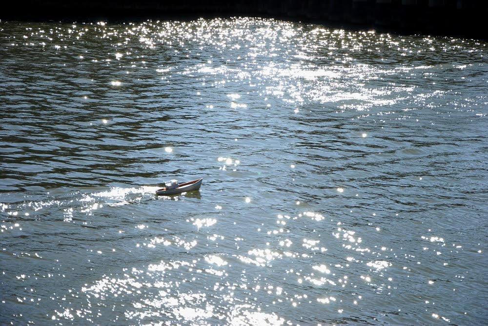
The murky waters of the Gowanus Canal are an unlikely lure for creativity. In spite of a century of pollution, a diagnosis of gonorrhea, and a history of spontaneous combustion, the canal has drawn artists to its banks for many decades. One of the foremost of these artists was Jose Gaytan, a photographer who lived just uphill from the waterway in a classic Park Slope brownstone. Gaytan photographed the canal nearly every day, until his recent death from cancer at age 61.

When Gaytan first moved to the area in 2002 from Manhattan, he wasn't sure how to spell Gowanus. But he soon found the canal to be a source of inspiration that would change his life. It started with his daily dog walks down to the water, and soon became a creative obsession. As Gaytan began bringing his camera to the canal, he discovered a rapidly changing landscape, and knew he needed to document it.

Over the course of the past 10 years, a slew of new hotels and luxury condominiums have encroached on this historically industrial neighborhood, bringing crowds to new bars and venues on once quiet streets. Jose Gaytan saw these changes, but focused his lens on a different side of the canal, capturing the decaying industrial landscape. "Many have taken photos of the Gowanus Canal," said Katia Kelly, publisher of the Brooklyn blog Pardon Me For Asking. “But I could sense immediately that his relationship with this industrial waterfront area went deeper. He seemed compelled to document every square inch of the area."

Photograph by Jose Gaytan

Photography meant everything to Jose Gaytan. It was his livelihood, his passion, and even the source of his marriage. He met his wife, Lisa Gaytan, while teaching a black & white photography class at the International Center of Photography. Their first dates were photo shoots, hauling equipment to the Brooklyn Bridge, waiting for the soft glow after sunset. Gaytan collected cameras of all kinds – from the newest digital equipment to antique film models – and was an expert in their use. He worked for years as a photography salesman and a freelance photographer.


His personal photographic projects focused on the waterfront of New York City. He was "drawn to gritty landscapes," said Lisa Gaytan. He photographed bridges under repair, the collapsed West Side Highway, and a series on Williamsburg, Brooklyn in the 1980's, "when there were wild dogs running up and down Kent Avenue," according to Lisa Gaytan. The allure of the Gowanus Canal, with its abandoned buildings, empty lots and crumbling infrastructure, was not hard to understand.


Photograph by Jose Gaytan

Despite his many decades of photographic work, critical acclaim eluded Jose Gaytan until almost the end of his life. His first solo exhibit was at age 58, at the Brooklyn Public Library, with an overview of his Gowanus photographs titled Brooklyn in Transition: A Photographic Essay of the Gowanus. The exhibit "was his major breakout," said Lisa Gaytan, and "was such an important thing for him." He worked day and night to prepare for the show, shooting and printing an enormous catalog of images.

The exhibit opened June of 2009 and presented a collection of sublime Gowanus landscapes. Inky clouds, brilliant sunsets, crusty tires, beautiful decay. It was a unique take on a toxic waste site. At the library, responses from visitors "ranged from a sense of wonder, to disbelief that this was the same Gowanus that most Brooklynites were familiar with," said Barbara Wing, Director of Exhibitions at the Brooklyn Public Library. 


The exhibit received a glowing review from the New York Times, which compared Gaytan's photographs to the Impressionist canvasses of Pierre-Auguste Renoir. “I loved that he was in this corner of the city - that is usually written off as some polluted hellhole - finding moments of serenity,” said David Gonzalez, an editor at the New York Times photojournalism blog Lens, who reviewed the exhibition. "His palette was sophisticated, betraying a master’s understanding of light and color. Jose was an underappreciated master."


Photograph by Jose Gaytan

The exhibit and the NY Times review were “the culmination of everything he had worked for,” said Gaytan's friend Katia Kelly. "He was so excited." However, in just two years, an aggressive form of cancer, multiple myeloma, created a host of complications which would keep him from continuing his photographic work.

“I think he knew that he didn't have any time left,” said Lisa Gaytan. Unable to go out and shoot on the Gowanus, he began scanning negatives late into the night, trying to organize his vast photography archive from the past 40 years. Last December, Gaytan died. Some of his final words, according to his close friend Angel Franco, a New York Times photographer, were: "I love photography."

Gaytan was unable to finish organizing his archives before he died. Scattered around his office, on hard drives and in boxes of slides, there is a treasure trove of surprises from the Gowanus. They reveal a patient photographer, circling his subject, considering it from all angles. "Photographing the Gowanus was his love letter to Brooklyn," said Lisa Gaytan. "I’m very proud of what he did."


Photograph by Jose Gaytan

Fifth Anniversary

Inside The Drydock (2006)

March 2012 -

This month marks the fifth anniversary of this website, which was started in March 2007. Over the past five years, New York City has undergone an enormous amount of change. The photo essays on this website have attempted to document some portion of that change. An archive of approximately 100 photo essays has been amassed here, documenting a city in the process of erasing its past, from the destruction of Brooklyn's historic industrial waterfront, to the use of eminent domain to condemn unique neighborhoods like Manhattanville and The Iron Triangle, to the demolition of New York's few remaining bungalow communities in New Dorp, Brighton Beach and the Rockaways. Over the past five years, thousands of historic older structures have disappeared from New York's landscape and have been replaced by new buildings, mainly in the form of luxury condominiums and chain stores. The thousands of photographs taken for this website have captured only a small amount of that transformation.

These photographs and photo essays can be traced back to one photograph and one essay from Red Hook, Brooklyn, a neighborhood that is emblematic of the transformation of New York's landscape. The photograph, titled "Inside The Drydock," was taken in 2006 inside the Todd Shipyard, a Red Hook ship repair facility that was built before the Civil War and destroyed in 2007 to make way for Ikea's first big box store in New York City. Soon after its demolition, an even larger portion of Red Hook's historic industrial waterfront was destroyed, as predicted in an essay written in 2006 titled "Beard Street, Red Hook, Brooklyn." This essay includes many of the motifs later explored on this website: the post-industrial waterfront, the legacy of Robert Moses, endangered historic neighborhoods, hidden landscapes, burnt out cars, packs of wild dogs.

This photograph (included above) and this essay (included below) were both exhibited at the Brooklyn Public Library as part of their "My Brooklyn" exhibition series. The dialogue that they created about the changing Brooklyn waterfront inspired the creation of this website, as well as a solo show at the library in 2008 titled "Twilight on the Waterfront: Brooklyn's Vanishing Industrial Heritage." Much of Brooklyn's historic industrial waterfront has since been erased from the landscape, along with countless other New York neighborhoods and landmarks, demolished to make way for new development. As the evolution of the city continues, the archive of photo essays continues to grow.


Four Panes (2006)

Beard Street, Red Hook, Brooklyn (2006)

One day at sunset I slipped into an abandoned building in Red Hook, disturbing no one but a family of pigeons. As I watched the light fade through the four panes of an old factory window, I looked out onto an empty lot and up along Beard Street, my favorite street in Brooklyn. The quiet of the street, the emptiness of the factory and the dying light brought me to ruminate on the nature of change in Brooklyn.

When I walk these few blocks along the southern edge of Red Hook I often think of the history that has preceded me. Sixty years ago, the view from this factory window would have been entirely different. Stevedores and boat builders, dockhands and dry dock workers, saloons overflowing with noon time workers out for a nickel beer and free lunch. From stories told to me by the few remaining old timers still in the neighborhood, I feel connected to a Red Hook that was a lively place to grow up, a working waterfront, full of tight knit families, kids in the streets, with shops and restaurants on every corner.

For decades Red Hook has been an isolated outpost of Brooklyn’s waterfront, cut off by Robert Moses and his BQE, without a proper subway station. The community changed from its industrial waterfront days, its core replaced by massive housing projects and their new way of life. Along the edges, a few artists found perches in converted factories and warehouses. This is the Red Hook I have seen, a fascinating mix of decrepit old Brooklyn, newly emerging artists and housing project families.

Beard Street, only a few blocks long, is paved in rough cobblestones so uneven that the constant flow of heavy orange school buses bounce almost out of control. Beard Street can feel like the edge of the world, a series of empty lots and buildings waiting for something to come along. But beneath the surface solitude, there is a secret vibrancy to the street. Anything can happen here. Along Beard Street I have been confronted by a pack of wild dogs and met the Queen of Rockabilly. Every week a new wave of street art and stencils cover the walls of the civil-war era shipping warehouses, delicate depictions of moths and birds flying from red brick confines; solitary life-size paper figures trudging along wooden walls. Anything might appear on the street - one day a smoldering burnt out car arrives, destroyed for some sordid purpose, soon vanishing. Another day a pink toilet sits in the snow near hundreds of losing lottery tickets.

Further along the street, an abandoned sugar refinery is slowly falling into gray water. Nearby the sunken mast of an old boat protrudes from the swells. Some of the old buildings are filled with massive graffiti pieces, illuminated by raw light streaming through window frames without glass. Other buildings, like those on the Beard Street Pier are filled with artists, glassblowers. At night a nondescript metal shutter raises to reveal Lillie’s Bar - the last business on the street - and the cobblestones bark with drunken footsteps.

This is the only street in Brooklyn I am compelled to visit again and again. I have walked along these ragged sidewalks countless times. I have taken hundreds of photographs here. There is a rare visual poetry to absorb.

In a few years the view from an abandoned factory onto this street will be completely different, if a window even continues to exist. All things must change in a city and Beard Street is no exception. A sea of parking lots, a new big-box store and crowds of shoppers are scheduled to soon replace the old factories and warehouses. Already buildings are being sold and torn down. Much as I would like the isolation and the element of urban surprise to remain, this will no longer be. Will the cobblestones remain?

I find the dynamic between history, present-day and future in Brooklyn especially captivating. A view of Beard Street speaks to me of one kind of neighborhood fading into the past as a new one develops a future. It compels me to seek out those in-between places yet to be rebuilt that have a secret life to spark the imagination.

The Newtown Creek Armada Update


February 29th, 2012 -

The Newtown Creek Armada is currently being built in a studio overlooking the Newtown Creek. Several prototype boats have been created and tested in the toxic waters of this Superfund Site. Initial voyages are embarking at various points along the creek, including the difficult-to-access waters of the Dutch Kills, English Kills, and Maspeth Creek. A variety of waterproof camera systems have been tested, and exploratory footage has been captured. To date, no boats have been lost.

The Newtown Creek Armada is an interactive installation in which a model boat pond will be created on the Newtown Creek, one of America's most polluted waterways. The installation will take place in Spring 2012, when visitors will be invited to pilot a fleet of artist-created, miniature, radio-controlled boats along the Newtown Creek's surface. The Armada is a collaboration between Nathan Kensinger, Laura Chipley and Sarah Nelson Wright and is presented in partnership with The North Brooklyn Public Art Coalition (nbART), which announced the project in November 2011.

Since the project was announced, it has been featured in the New York Daily News, L Magazine, DNA Info, and the Brooklyn Paper. In January 2012, it received a grant from FEAST, and in March, it will receive a grant from the Brooklyn Arts Council in a ceremony at Brooklyn Borough Hall.

The following images are of prototype boats from The Armada, on their initial exploratory voyages. For more information on The Armada, please visit the project's webpage at www.newtowncreekarmada.org


New Website

February, 2012 -

As the 5th anniversary of this photography website approaches, I have created a new website to highlight some of the films and installations which I have been working on. You can view descriptions of these projects, along with several photography portfolios, a bio and CV at www.nathankensinger.com

Please email me at thegowanus [at] yahoo.com with any questions.

Chemical Lane, Staten Island


January 31, 2012 -

The Arthur Kill - a tidal strait dividing Staten Island and New Jersey - is one of the most abused waterways in New York City. Its salt water marshes and fresh water wetlands have been used for over a century as an enormous dumping ground, and it has been poisoned by raw sewage and oil spills. After decades of heavy use, its shoreline in western Staten Island is now a series of post-industrial wastelands. Traveling south down the Arthur Kill, these include the demapped streets of Bloomfield's oil tanker fields, the unnatural hills of the Fresh Kills Landfill, the moldering wrecks of the Rossville boat graveyard, and the abandoned LNG gas tanks at Chemical Lane. All of these wastelands face New Jersey's infamous Chemical Coast, located just across the Kill.


Today, the New York City Economic Development Corporation (NYEDC) is planning to redevelop a section of Staten Island's polluted, abandoned coastline. It is offering up "the largest New York City-owned property available for maritime development," according to the Staten Island Advance, with "2,000 linear feet of shoreline along the Arthur Kill." This 33-acre lot is located at the foot of Chemical Lane, a desolate half-paved road that dead-ends in the Kill. The property is an overgrown wilderness, with dirt paths leading to several collapsing piers, and is part of a much larger abandoned industrial complex which includes the LNG gas tanks, a neighborhood landmark still considered to be "Staten Island’s most complex and ambitious project," according to the Staten Island Advance. These tanks have sat empty for over 30 years while nature has reclaimed the area, and in many ways, the clash between haphazard development and encroaching wilderness on Chemical Lane illustrates the troubled relationship that Staten Island has with the Arthur Kill.

Chemical Lane Paved


Chemical Lane Unpaved

The neighborhood around Chemical Lane was once a rural wilderness. "Twenty years ago, it was like upstate around here,” one neighborhood resident told the NY Times. “It was all woods. The old guys tell me they used to walk down the road with a gun and hunt." Today, much of that wilderness has been paved over by development or put to unnatural use. Chemical Lane currently houses a random assortment of businesses that are bluntly at odds with nature, including a golf range where you can tee off into the Arthur Kill, a topsoil company piled onto a muddy open plain, and a paintball field set up in a plastic-coated forest. Bordering these businesses are a prison which was built in 1976 and closed down this year, and a maritime scrapyard.

Chemical Lane's most visible structures, its towering gas tanks, were completed in 1975. "The 10-story tanks, which are 250 feet in diameter, have steel roofs and concrete walls 10 feet thick," according to the NY Daily News, and "were built to store liquefied natural gas safely, even if they were struck by a 747." Upon completion, they were "heralded as the world’s largest" liquefied natural gas (LNG) containers, according to the Staten Island Advance. But despite their monumental size and cost, the tanks were never used, due to safety concerns from the nearby community. They now sit abandoned, slowly rusting, covered in graffiti, and ringed by a dark forest littered with mattresses, boats, and abandoned buildings.

Forest Mattress


LNG Tank and Boat

Over the years, wildlife displaced from new development near Chemical Lane has found a home at the abandoned LNG gas tank property. A herd of deer wanders freely through the new-growth woods and hawks soar overhead. The property is also home to woodchucks, an owl and a muskrat, according to Puma Ghostwalker, a naturalist who works in the area. Puma, who recently rescued a baby deer stranded in the oil tanks' overgrown concrete canal system, is raising a bee colony nearby and has planted billions of wildflowers at the end of Chemical Lane, in an attempt to encourage the return of nature to this blighted area.

In spite of the abundant presence of wildlife on Chemical Lane, the Arthur Kill continues to be one of the most polluted bodies of water in New York City. "Thirty years ago, it was considered little more than an open sewer – dirtier at times than sewage flowing to treatment plants," according to the Staten Island Advance, and "was taking in 6 million gallons a day of raw sewage." An ongoing series of disastrous oil spills has mixed in with this human waste. In 1990 alone, the NY Times reported that the Arthur Kill suffered a 567,000 gallon oil leak from an Exxon pipeline, a 100,000 gallon oil spill from a barge explosion, a 37,000 gallon oil spill from a barge collision, a leaking gas barge, and a ruptured natural gas pipeline. Oil spills are still a regular occurrence, including a 2006 incident that dumped 31,000 gallons of Chevron crude oil into the water, killing a least one porpoise. "For people who live nearby," reported the NY Times, "it seemed business as usual."

Abandoned Pier on the Arthur Kill


Chemical Coast View

The NYEDC is now evaluating the proposals it has received for its property near Chemical Lane. Despite the looming reminder of the abandoned LNG oil tanks, it is "particularly eager to expand industrial maritime activity along the Arthur Kill," according to the Metropolitan Waterfront Alliance, as part of "a long-range plan called Working West Shore 2030" which calls for "20,000 new jobs in the West Shore over the next 20 years." There is no mention of deer, muskrat, bees or wildflowers in the West Shore plan, raising serious questions about what the ideal future for Chemical Lane should be. The city's main hope for the property, according to the NY Times, is to build "a new home for the sanitation department’s garage."

---
For more photo essays from the Arthur Kill, please visit Bloomfield, Staten Island (2011) and Fresh Kills (2009).


Tank Staircase


Leap House


View to the Kill


Platform Edge


Rusted Base


Foundation Collapse


Empty Boat


Paint Ball Forest


Ghost Tree


Target Wheel


Hollow Building


Sewage Flow


Canal System


To The Arthur Kill


Walkway Over The Kill


On The Kill


Fresh Kills Landfill